

Geographic information plays an important role in modern decision-making. Businesses, government agencies, researchers, students, and professionals use digital maps to understand locations, identify patterns, and manage spatial information. As technology continues to develop, online geographic information systems have become increasingly valuable because they allow users to access mapping resources through the internet.
The term ArcView Online is commonly associated with online access to ArcView-related GIS resources and web-based mapping tools. ArcView is historically known as geographic information system software developed by Esri. Meanwhile, ArcGIS Online is Esri’s cloud-based mapping platform that supports creating, managing, analyzing, and sharing geographic information through a web browser.
Understanding the relationship between ArcView and ArcGIS Online is important for anyone exploring online GIS technology. This guide explains the concept, features, applications, benefits, workflows, and practical considerations of ArcView Online and web GIS mapping.
1. What Is ArcView Online?

ArcView Online generally refers to online resources, mapping environments, or web-based access associated with ArcView and GIS technology. ArcView was developed by Esri as a geographic information system that helps users visualize, query, organize, and analyze location-based data.
Traditional ArcView software was primarily designed for desktop use. It enabled users to work with geographic datasets, create maps, examine spatial relationships, and generate reports. Over time, GIS technology developed into cloud-based platforms that allow users to access maps and spatial information online.
ArcGIS Online is Esri’s web-based platform for creating, sharing, and using GIS resources. Users can create interactive maps, store geographic content, share information with others, and access mapping applications through internet-connected devices.
Although ArcView and ArcGIS Online are related through Esri’s GIS technology ecosystem, they are not identical products. ArcView is associated with earlier desktop GIS software and licensing levels, while ArcGIS Online is a cloud-based platform.
For users searching for ArcView Online, understanding this distinction helps them choose the right GIS tool for their needs.
2. Key Features of ArcView Online and Web GIS Mapping

Web GIS platforms provide several features that make geographic information easier to access and understand. These tools help users transform raw spatial datasets into useful visual information.
Interactive Digital Maps
Interactive maps allow users to explore geographic information dynamically. Users can zoom in, zoom out, move across locations, and select map features to view additional details.
For example, a city planner can examine roads, buildings, parks, and public facilities on a single map. Interactive mapping improves understanding because users can explore information instead of viewing a static image.
Layer-Based Mapping
GIS maps commonly use layers to organize different categories of information. A map may include separate layers for roads, land use, population, water bodies, and administrative boundaries.
Users can enable or disable layers depending on the information they want to examine. This approach helps create organized maps that are easier to interpret.
Geographic Data Management
GIS platforms support the organization and management of spatial datasets. Geographic information may include points, lines, polygons, raster imagery, and attribute records.
Proper data management helps users maintain accurate and organized geographic information for mapping and analysis projects.
Online Sharing and Collaboration
Cloud-based GIS tools allow users to share maps and related content with colleagues, clients, teams, or the public, depending on access settings.
Collaboration is especially useful for projects involving multiple departments or geographically distributed teams. Users can work with shared information without always exchanging separate map files.
3. How ArcView Online and ArcGIS Online Work
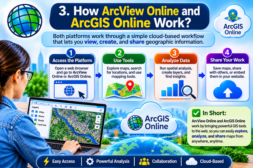
Web GIS technology combines geographic datasets, mapping software, internet connectivity, and visualization tools. A typical online GIS workflow begins with collecting or importing geographic information.
The user then organizes the data into layers. Each layer represents a specific type of geographic feature or information. For example, a transportation project may contain roads, traffic points, public transport routes, and construction locations.
The mapping platform displays these layers using a geographic coordinate system. Users can adjust the map appearance by changing symbols, colors, labels, and layer visibility.
When analysis is required, users may apply suitable GIS tools to examine spatial relationships. For instance, a user could identify facilities located within a particular distance of a road or compare population information across different areas.
After creating the map, users can save the project and share it with authorized audiences. Depending on the platform, maps can be shared through links, web applications, or embedded content.
A simple online GIS workflow includes:
- Collect geographic data.
- Upload or connect the datasets.
- Organize information into map layers.
- Configure symbols and labels.
- Explore or analyze spatial relationships.
- Save the map and share it with the intended audience.
This workflow makes geographic information more accessible and useful.
4. Benefits of Using ArcView Online for GIS Projects

Online GIS technology offers several advantages for individuals and organizations working with geographic information.
Accessibility
Web-based mapping platforms allow users to access GIS content through supported browsers and internet-connected devices. This can reduce the need to install desktop software on every device used for viewing shared maps.
Accessibility depends on account permissions, platform requirements, and internet availability.
Improved Collaboration
Online GIS environments can help teams work with shared maps and datasets. Different team members may review information, provide feedback, or access published content based on their assigned permissions.
This is useful for urban planning, environmental research, logistics, and business analysis.
Better Visualization
Geographic data can be difficult to understand when presented only in spreadsheets or long reports. Maps make location-based patterns easier to recognize.
For example, a business can visualize customer distribution across regions, while an environmental team can display land cover and natural resource information.
Efficient Information Sharing
Sharing online maps can simplify communication. Instead of distributing multiple static images, users may provide access to an interactive map that allows viewers to explore the information themselves.
Support for Data-Based Decisions
GIS mapping can help decision-makers identify geographic patterns, compare locations, and understand spatial relationships. However, the quality of decisions depends on the accuracy, completeness, and suitability of the underlying data.
5. Common Applications of ArcView Online and Web GIS

Web GIS mapping can be used across numerous industries. Its value comes from the ability to connect geographic locations with relevant information.
Urban Planning and Infrastructure
City planners can use GIS maps to examine roads, buildings, public services, land use, and development areas. Mapping these elements together can support planning discussions and infrastructure assessments.
Environmental Monitoring
Environmental professionals may use geographic information to study forests, rivers, wetlands, soil conditions, and land cover. Maps can help visualize changes over time when suitable datasets are available.
Business and Marketing
Businesses can analyze geographic customer distributions, market areas, store locations, and delivery zones. Location-based analysis may help organizations compare potential sites and understand regional demand.
Transportation and Logistics
GIS mapping supports the visualization of road networks, delivery locations, transport routes, and service areas. Organizations may use spatial analysis to evaluate route options and distribution coverage.
Education and Research
Students and researchers can use GIS technology to study geography, population patterns, natural resources, urban growth, and other spatial topics.
Online maps can also make research findings easier to communicate to audiences who may not have specialized GIS software.
6. How to Get Started with ArcView Online

People interested in online GIS mapping should first identify the tool they actually need. If the goal is to use a modern cloud-based Esri mapping platform, ArcGIS Online is a relevant option to explore.
Step 1: Identify Your Mapping Goal
Decide whether you want to create a map, analyze geographic data, share a project, or learn GIS concepts. A clear goal helps you choose suitable tools and datasets.
Step 2: Explore the Platform
Review the available GIS platform features and account requirements. ArcGIS Online provides web-based mapping functionality, but specific capabilities may depend on account type, licensing, and permissions.
Step 3: Prepare Geographic Data
Collect reliable data in supported formats. Check whether the dataset includes geographic coordinates, attributes, and useful metadata.
Poor-quality or incomplete data may produce misleading maps.
Step 4: Create a Map
Add the required data layers and configure their visual appearance. Use clear labels, appropriate symbols, and readable colors to make the map easy to understand.
Step 5: Review and Share
Check the map for accuracy, readability, and missing information. Set sharing permissions carefully before publishing or distributing the map.
Beginners can improve their skills by practicing with small datasets before moving to complex GIS projects.
7. ArcView Online vs. Traditional Desktop GIS

Online GIS and desktop GIS tools serve related purposes, but they differ in their workflows and access methods.
Traditional desktop GIS software is installed on a computer. It may provide extensive functionality for editing, processing, and analyzing geographic datasets. Desktop applications can also be useful when working with large datasets or specialized workflows that require local processing.
Online GIS platforms operate through web-based environments. They can simplify map sharing, collaboration, and access to published geographic content.
The most suitable approach depends on the project.
A user who primarily needs to view and share interactive maps may prefer an online GIS platform. A professional who requires advanced local data processing or specialized editing may need desktop GIS software.
Some GIS workflows combine both approaches. Users can prepare or analyze data with desktop tools and then publish maps to an online platform for collaboration and sharing.
It is important to compare current software features, licensing, data requirements, and compatibility before selecting a platform.
Conclusion
ArcView Online is a search term connected with ArcView GIS and the broader development of web-based geographic information systems. For users interested in modern cloud mapping, ArcGIS Online is an important platform to understand because it supports interactive maps, geographic data management, collaboration, and online sharing.
GIS technology helps individuals and organizations make geographic information easier to visualize and interpret. Its applications range from urban planning and environmental monitoring to business analysis, transportation, and education.
Choosing the right GIS solution requires understanding your project goals, data requirements, technical needs, and platform capabilities. By learning the fundamentals of GIS mapping and practicing with reliable geographic datasets, beginners and professionals can build valuable skills and use location-based information more effectively.
8. Frequently Asked Questions About ArcView Online
1. What is ArcView Online?
ArcView Online is a term used for online resources or web-based GIS access associated with ArcView mapping technology. Users searching for modern cloud GIS mapping may also be looking for ArcGIS Online.
2. Is ArcView Online the same as ArcGIS Online?
No. ArcView is historically associated with Esri’s desktop GIS software, while ArcGIS Online is a cloud-based mapping platform. They are related within Esri’s GIS ecosystem but are not the same product.
3. Can I create maps using ArcView Online?
Online GIS platforms such as ArcGIS Online allow users to create and share interactive maps. The available tools depend on the platform, account, and permissions.
4. What is GIS mapping used for?
GIS mapping is used to visualize, manage, and analyze geographic information. Common applications include urban planning, environmental monitoring, transportation, business analysis, and research.
5. Is ArcGIS Online suitable for beginners?
ArcGIS Online can be a useful starting point for people learning web GIS. Beginners should start with basic map creation, layer management, and simple geographic datasets.
6. What types of data are used in GIS mapping?
GIS may use point, line, polygon, raster, imagery, and attribute data. Examples include addresses, road networks, administrative boundaries, satellite imagery, and population records.
7. Can online GIS maps be shared with other people?
Yes. Online GIS platforms commonly support sharing maps and related content. Users must select appropriate sharing settings and permissions.
8. Does ArcView Online require internet access?
Web-based GIS services generally require internet access to use their online features. Traditional desktop GIS software may support some offline workflows, depending on the software and configuration.
9. What industries use online GIS mapping?
Industries that use online GIS mapping include government, transportation, environmental management, real estate, education, utilities, logistics, and business marketing.
10. How can I learn ArcView Online or web GIS?
Start by learning basic GIS concepts, map layers, geographic data formats, and coordinate systems. Practice creating simple maps using a web GIS platform and gradually explore spatial analysis and sharing features.